Our Monday morning now and we paralleling the coast of Malaysia, making our way north towards Thailand. Originally stemmed to berth in Phuket, we were informed some weeks ago that the pier there was occupied by another vessel and so instead we are anchoring in Patong Bay.
Phuket is on the east side of the peninsular, whereas Patong bay is on the west; as the peninsular is relatively narrow, the difference is minor, except of course we have to tender guests ashore. Personally I prefer to stay away from the port berth; I have had personal experience of the taxi drivers there. They are a law unto themselves, take people where they (the drivers) want instead of where the passengers actually want to go and are generally obnoxious. As they are the only group allowed into the port, there is little choice of alternatives. At least, on the Patong Bay side, we are tendered in next to an area adjacent to a main road and therefore one has more choice.
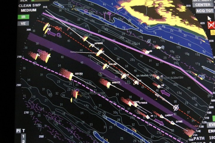
It was another long night of course, additional manning on the Bridge was required and I, Gerd and Michel, our 1st officer, did turn-about up there. I managed to get a photo of our radar without flash; cranking up the ISO and opening the aperture worked well and none of us lost our night-vision. 
So here we are, in the west-bound lane; imagine you are looking down from an aircraft and this is a ‘birds-eye’ view. We have the circle around us; the thick magenta line to the north, marks the northern boundary of the Traffic Separation scheme; the dotted magenta below us marks the southern side of the TSS. The broad purple shaded area is the boundary between the 2 lanes, a ‘no go’ area, (unless one needs to cross it of course). Our lane is about 1 -mile wide at this point and just to the north of us is a sandbank, which you can see outlined with soundings, (depths). Down to the south, the east-bound line has the same challenge, sandbanks to their south. The coast of Malaysia is bright yellow and the blue shaded area is really shallow, don’t wanna go there 
The vessel ‘targets’ can be seen, with their vectors, (a resultant of their course and speed). The ones ahead of us are in the same lane and going the same way; the ones over to the south of us are in the east-bound lane; there is about a mile passing distance between those nearer. 2 of these ‘targets in the east-bound lane are VLCCs, or Very Large Crude Carriers, (Tankers). They draw 22 metres, in other words, about 70 feet of their hull is underwater, they are vast juggernauts . They display 3 red lights vertically, as well as their navigation lights. They are ‘restricted in their ability to manoeuvre’, (the understatement of the year)! Other vessels are meant to keep out of their way. When one considers how relatively shallow the Straits are, there are very few options open to them, as far as where they can go that is.
In the wee hours, we began to experience a thick haze, not fog or mist, but wood smoke coming from the Malaysian mainland, there must be a great deal of forest burning going on up there. However, at 9 this morning we cleared it, visibility improved and, because we had reached the north extremity of the lanes, the west-bound ships, having more sea-room began to ‘scatter’, heading for their respective destinations, while the east-bound, approaching the TSS, were beginning to converge, however many miles away from us.
We are due to arrive at Patong Bay anchorage at 7 a.m. tomorrow, so, all being well, photos of Thailand to follow……


